Scale & Coordinate Issues
Typically, a design file will be based upon existing plan and DTM data provided by others and the coordinate system and scale will already be determined by that data. One situation where problems may occur is with the insertion of model elements from another file, or third party content such as cars, details, etc. If the file origin is another Microstation drawing, the scale conversion is usually automatic, but if the source of the file is from outside of Microstation, the scale may be unrecognized.
Scaling Objects
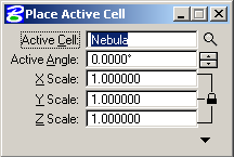
Most external objects will be inserted as cells or references. If the object or file being inserted is to always be used at the same scale, i.e. feet, it is easiest to set the original file to the correct scale so it will insert correctly as a cell. The Place Cell dialog does, however allow for a scaling of the cell on insert.

The reference manager has similar scale and rotation settings for reference files as well.
The scale will almost always be off by some predictable amount based on a mismatch of feet and inches or metric to imperial. A good conversion calculator is invaluable for determining these scale factors.
