
USA Banner

Official US Government Icon

Official websites use .gov
A .gov website belongs to an official government organization in the United States.

Secure Site Icon

Secure .gov websites use HTTPS
A lock ( ) or https:// means you’ve safely connected to the .gov website. Share sensitive information only on official, secure websites.

U.S. Department of Transportation U.S. Department of Transportation Icon United States Department of Transportation United States Department of Transportation

Noteworthy Practices

Left Nav - HSA Learn Safety

Crash Modification Factors in Practice: Using CMFs to Quantify the Safety Performance of Design Decisions and Exceptions - California and Missouri

Summary from Crash Modification Factors in Practice: Using CMFs to Quantify Safety in the Development and Analysis of Alternatives

(The case studies begins on Page 18 of the full report, after background information about the use of crash modification to quantify the safety performance of design decisions and exceptions.)


Background

Crash Modification Factors (CMFs) can be applied in the development and analysis of alternatives to estimate the safety performance when the advantages and disadvantages of each alternative are considered. The following case studies illustrate how CMFs have been applied by the California Department of Transportation (Caltrans) and the Missouri Department of Transportation (MoDOT) in the development and analysis of alternatives.

Case Study #1: California

The following case study illustrates how the Observed Crash Frequency with CMF Adjustment method has been used to assess the safety impact of individual design elements and evaluate the overall impact of design exceptions on the safety performance of a facility. Information for the case study was provided by Caltrans.

Project Description

In response to 24 collisions that occurred in a three-year period within a section of US 199 in Northern California, District 1 of Caltrans proposed a series of engineering improvements to address potential safety issues. The project limits are within United States Forest Service Lands in Del Norte County, approximately two miles north of Hiouchi. The limits extend from 0.9 to 1.1 miles north of South Fork Road. The existing alignment consists of two curves with a short tangent transition, forming a reverse curve. Curve 2 was the primary focus of the engineering improvements as all 24 crashes occurred along this curve during the three-year period.

Findings

CMFs can be applied to quantify the safety impacts of design elements and estimate the effects of mitigation measures. Combined, these results can be used to evaluate the overall impacts of design exceptions on the estimated safety performance of a facility. In this case, District 1 of Caltrans used CMFs in order to quantify the safety impacts of increasing the radius of a curve, increasing the superelevation, increasing the width of the travel lane, and increasing the shoulder width. Even though some of the proposed changes did not meet the design standard based on California's design documents, the use of CMFs demonstrated that the proposed improvements could result in a substantial reduction in crashes compared to the existing conditions. Further analysis could compare the estimated safety impact of proposed design exceptions with respect to design standards. The results of the safety analysis could also be considered in conjunction with other factors such as project cost, operational performance, and environmental impacts.


Case Study #2: Missouri

The following case study illustrates how the Predicted Crash Frequency with CMF Adjustment method has been used to assess the safety impact of individual design elements and evaluate the overall impact of design exceptions on the safety performance of a facility. Information for the case study was provided by the Missouri Department of Transportation (MoDOT).

Project Description

MoDOT Central District proposed a project on a rural, two-lane section of Route 42 in Kaiser, MO. The existing conditions included a narrow cross-section with lane widths of 10.5 feet and unpaved shoulders. The proposed conditions included paved shoulders (2 feet in both directions) and shoulder and centerline rumble stripes. The design guidelines for minor roads in Missouri identify minimum expectations for several design features, including a consistent shoulder width of 2 to 4 feet. In this case, the District conducted an analysis, using Part C Predictive Methods of the HSM, to document the potential safety benefits of the proposed conditions compared to the existing conditions. A separate analysis is also provided to compare the safety performance of different shoulder widths (2 feet versus 4 feet).

Findings

SPFs can be used to predict crashes for baseline conditions and CMFs can be applied to adjust the baseline estimate to reflect specific conditions of interest. This is useful for quantifying and comparing the safety performance of scenarios with different design features and can aid in the decision-making process. Specifically, this approach can help an agency to better understand the potential safety impacts of individual design elements and design exceptions. MoDOT conducts similar safety analyses as part of the evaluation of design exceptions that involve safety related features. In this case, Central District of MoDOT used the Predicted Crash Frequency with CMF Adjustment method in order to quantify the safety impacts of installing a paved shoulder with shoulder and centerline rumble stripes. Two different scenarios are compared to the existing conditions. The proposed condition included a paved shoulder width of two feet, while the alternative condition based on design guidelines is a paved shoulder width of four feet. The use of this quantitative method demonstrated that the proposed improvements could result in a substantial reduction in crashes compared to existing conditions. Recall that non-calibrated SPFs may overestimate or underestimate the predicted crash frequency, but provide a reasonable estimate of the percent difference in crashes among alternatives. As such, it is desirable to use a calibrated SPF if it is necessary to estimate the change in predicted crash frequency or conduct a formal economic analysis.

Read the full practice →

Contact

Karen Scurry
FHWA Office
609-637-4207
Karen.Scurry@dot.gov

Publication Year: 2013

View more information about CMFs on the web at: http://safety.fhwa.dot.gov/.
Additional practices in the CMFs in Practice Series:

Crash Modification Factors in Practice: Quantifying Safety in the Development and Analysis of Alternatives - Arizona and Colorado Case Studies

Summary from Crash Modification Factors in Practice: Using CMFs to Quantify Safety in the Development and Analysis of Alternatives

(The case studies begins on Page 17 of the full report, after background information about the use of crash modification development and analysis of roadway safety alternatives.)


Background

Crash Modification Factors (CMFs) can be applied in the development and analysis of alternatives to estimate the safety performance when the advantages and disadvantages of each alternative are considered. The following case studies illustrate how CMFs have been applied by the Colorado Department of Transportation (CDOT) and the Arizona Department of Transportation (ADOT) in the development and analysis of alternatives.

Case Study #1: Colorado

The following case study illustrates how the Observed Crash Frequency with CMF Adjustment method has been used to assess the safety impact of alternatives. Information for the case study was provided by CDOT.

Project Description

Castle Rock, Colorado lies south of Denver along the Interstate 25 corridor. To accommodate growing development in the area, CDOT considered a new interchange on I-25. In addition to the “no build” scenario, they considered two alternatives for the new interchange design. Alternative 1 would extend one road, Castlegate Drive, to create the new interchange. Alternative 2 would extend another road, Atrium Drive, to create the new interchange.

As part of the environmental assessment of the project in 2009, CDOT conducted a safety analysis to evaluate the effect on crashes for the proximate roadway segments and intersections, including ramp junctions. The full safety analysis developed estimates of crash predictions for each segment and junction based on either Safety Performance Functions (SPFs) (for segments) or comparisons to similar intersections in the area (for intersections). At the time of the analysis, CDOT did not have available SPFs for intersections.

Findings

This case study presented an example of how CMFs can be applied to estimate the safety impacts of various alternatives. The safety analysis presented in this case study was just one piece of the overall safety analysis conducted for the proposed interchange alternatives. In addition to the safety analysis of the alternative junction types, CDOT developed crash estimates for each segment and intersection within the study area. The result was an estimate of annual crashes for the entire study area for Alternatives 1 and 2. The estimated safety performance of each alternative can then be considered with the operational performance, project costs, environmental impacts, and other factors to identify a balanced design and the most desirable alternative.


Case Study #2: Arizona

The following case study illustrates how the Expected Crash Frequency with CMF Adjustment method has been used to quantify the safety impacts during the development and analysis of alternatives. Information for the case study was provided by ADOT.

ADOT is performing predictive analyses following the procedures in the AASHTO Highway Safety Manual at the scoping and alternative selection stage of demonstration projects. They are working to develop a framework for integrating substantive safety considerations into the ADOT project planning and development process.

Project Description

ADOT identified potential safety improvements on a 24.6 mile section of Arizona State Route 264 (SR 264) and evaluated the potential safety impacts during the analysis phase of the development and analysis of the alternatives. SR 264 is a rural, two-lane road in northeastern Arizona and functionally classified as a minor arterial. Figure 2 identifies the general location and limits of the study section.

Findings

This case study presented an example of how the Expected Crash Frequency with CMF Adjustment method can be used to estimate the expected safety impacts of various design alternatives. ADOT used SPFs and CMFs from the Highway Safety Manual (HSM) in this analysis, supported by the Interactive Highway Safety Design Model (IHSDM) software. They also incorporated observed crash history, using the Empirical Bayes method, to estimate the expected crashes for various scenarios. The result was an estimate of total expected crashes for the entire study section over a 20-year analysis period. This allowed for a quantitative comparison of the safety performance for two design alternatives and the existing conditions. ADOT used the results of the crash analysis in a benefit-cost analysis to help select the most cost-effective alternative.

Contact

Karen Scurry
FHWA Office
609-637-4207
Karen.Scurry@dot.gov

Publication Year: 2013

View more information about CMFs on the web at: http://safety.fhwa.dot.gov/.
Additional practices in the CMFs in Practice Series:

Crash Modification Factors in Practice: Quantifying Safety in the Roadway Safety Audit Process - Michigan Case Study

Summary from Crash Modification Factors in Practice: Quantifying Safety in the Road Safety Audit Process

(The Michigan case study begins on Page 11 of the full report, after background information about the use of crash modification factors in the Roadway Safety Audit process.)


Background

Crash Modification Factors (CMFs) can be applied in the Roadway Safety Audit (RSA) process to quantify the safety effects of various treatments and justify the RSA team suggestions to the project owner and/or design team. The following case study illustrates how CMFs have been applied in the RSA process. It also identifies noteworthy practices and actual challenges encountered by agencies with respect to this process.

Project Description

The Michigan Department of Transportation (MDOT) conducted an Operational and Preliminary Design Stage RSA along the first horizontal curve on M-26 north of the village limits of South Range, in Houghton County. The RSA location is circled in Figure 2. This curve was chosen by MDOT on the basis of crash history.

The objectives of the RSA were to:

  • Review road safety at the curve.
  • Identify physical and operational issues that may affect road safety.
  • Review the proposed plan concept.
  • Develop and evaluate potential countermeasures to reduce the frequency and severity of collisions.

Findings

The RSA process is typically a qualitative evaluation of the safety performance of a given facility. The RSA report is generally the final deliverable of an RSA team, including a list of potential safety issues and associated countermeasures. It is then the responsibility of the project owner/design team to consider the suggestions identified by the RSA team and determine which countermeasures will be implemented and the relative timeframe for implementation. The application of CMFs not only helps an agency to compare the relative effectiveness of suggested countermeasures, but it also provides information to be used in a benefit-cost analysis. A benefit-cost analysis can be used to prioritize suggested improvements and may be required when applying for funding.

Contact

Karen Scurry
FHWA Office
609-637-4207
Karen.Scurry@dot.gov

Publication Year: 2013

View more information about CMFs on the web at: https://safety.fhwa.dot.gov/.
Additional practices in the CMFs in Practice Series:

  • Quantifying Safety in the Roadway Safety Management Process - Virginia Case Study
  • Quantifying Safety in the Development and Analysis of Alternatives - Arizona and Colorado Case Study
  • Using CMFs to Quantify the Safety Performance of Design Decisions and Exceptions - California and Missouri
  • Evaluating Opportunities Using Predicted Crash Frequency with CMF Adjustment - Missouri Case Study
Crash Modification Factors in Practice: Quantifying Safety in the Roadway Safety Management Process - Virginia Case Study

Summary from Crash Modification Factors in Practice: Quantifying Safety in the Roadway Safety Management Process

(The Virginia case study begins on Page 7 of the full report, after background information about the use of crash modification factors to quantify roadway safety.)


Background

In 2007, the Virginia Department of Transportation (VDOT) started a new program, Strategically Targeted Affordable Roadway Solutions (STARS), aimed at critical safety and congestion hot spots throughout the State. The primary goals of the STARS program are to identify roadway improvements on the interstate and primary systems that:

  • Are relatively low-cost.
  • Address existing mobility and safety problem areas.
  • Require minimal preliminary engineering and right-of-way.
  • Can be implemented quickly (24 months or less).

The STARS program allows VDOT to better incorporate operations and safety into the long-term planning process and involves the following four steps.

  1. Study area selection.
  2. Detailed safety and operational analysis.
  3. Prioritization of recommendations.
  4. Programming and implementation.

In this process, the study team identifies potential safety and operational issues in Step 2 along with a list of potential countermeasures. Crash Modification Factors (CMFs) are then applied in Step 3 to help justify and prioritize the suggestions. Specifically, CMFs are used to estimate the safety impacts associated with each countermeasure.

Findings

There are several potential benefits associated with the application of CMFs in the safety management process. Specifically, CMFs provide a means to quantify the safety impacts of decisions and help to raise awareness of safety. The application of CMFs also helps to prioritize potential treatments and provides decision-makers with the information needed to identify cost-effective strategies. VDOT indicated that the STARS program has helped to raise awareness of safety issues at both the State and local level, which has led to more safety-focused projects.

The goal of the STARS program is to identify where safety and congestion issues overlap on the State's roadways. As demonstrated in the case study, CMFs are used in the benefit-cost analysis to quantify the safety impact of the suggested countermeasures. The results of the benefit-cost analysis are beneficial in the prioritization of recommendations as well as the programming and implementation stage. VDOT indicated that STARS-based projects have addressed more crashes and typically involve lower impact treatments (less utility and right of way) that can be implemented more quickly than proposals submitted prior to the STARS program.

Using CMFs as part of the benefit-cost analysis is not only beneficial to prioritizing the suggested countermeasures for a particular site, but also helps in the management of a safety program. The STARS program actively utilizes Highway Safety Improvement Program (HSIP) funds for many of the hot spot locations throughout the State. The CMFs used in the benefit-cost analysis are instrumental in the application process for HSIP funding.

Contact

Karen Scurry
FHWA Office
609-637-4207
Karen.Scurry@dot.gov

Publication Year: 2013

View more information about CMFs on the web at: https://safety.fhwa.dot.gov/.
Additional practices in the CMFs in Practice Series:

  • Quantifying Safety in the Roadway Safety Audit Process - Michigan Case Study
  • Quantifying Safety in the Development and Analysis of Alternatives - Arizona and Colorado Case Study
  • Using CMFs to Quantify the Safety Performance of Design Decisions and Exceptions - California and Missouri
  • Evaluating Opportunities Using Predicted Crash Frequency with CMF Adjustment - Missouri Case Study

Tennessee DOT Local Roads Safety Initiative Assists Counties Challenged by Limited Staff with Road Safety Improvements

Summary from Assessment of Local Road Safety Funding, Training, and Technical Assistance: Benefit/Cost Tool and Local Road Safety Manual


Background

The Tennessee DOT (TDOT) Local Roads Safety Initiative (LRSI) was created in 2010 to assist with improving safety on local roads. TDOT created the initiative to assist its counties with road safety improvements. The initiative provides basic signing, striping upgrades, signage for curves, guardrail, and approaches to guard rails. Most counties have limited support staff and very few counties have staff with the needed engineering expertise. Only 6 of 95 county chief administrative officers are licensed engineers. The LRSI was developed by a partnership between the Strategic Highway Safety Plan (SHSP) and safety projects coordinator, State traffic engineer, assistant chief of operations, incident management division director, and the Tennessee FHWA Division. TDOT developed a consultant contract and hired two consultants to conduct local road safety analysis in Tennessee's 95 counties.

Benefit

The TDOT Local Road Safety Initiative has successfully conducted Road Safety Audit Reviews (RSARs) through the draft stage for 45 counties and 21 projects have been let to bid and awarded since the program's inception.

Contact

FHWA Office of Safety staff contacts by safety function

Ohio DOT and LTAP Provides Opportunities for Townships to Improve Town-wide and Corridor Signage at Intersections and Curves

Summary from Assessment of Local Road Safety Funding, Training, and Technical Assistance: Benefit/Cost Tool and Local Road Safety Manual


Background

The Ohio DOT's (ODOT) Office of Local Programs, with the assistance of the Ohio Local Technical Assistance Program (LTAP) Center, administers a systemic signage intersection and curve upgrade program for targeted Ohio Townships. The program provides two opportunities for townships to apply for free safety and advanced warning signs.

  • The Township-wide Systematic Signage Upgrade Program is for Townships with a high number of severe crashes. The Top 50 Townships with a high number of serious crashes for a five-year period are invited to apply for funding to implement systematic signage upgrades.
  • The Township Corridor Systematic Signage Upgrade Program provides intersection signage and curve upgrades for Townships with a corridor among the Top 50 Township High-Risk Rural Roads in Ohio based on a five-year period of crash data. Townships can apply for funding on designated corridors.
  • Townships participating in the programs are responsible for installation and maintenance of the signage and are limited to a list of preapproved signs.

As a part of the program, the Ohio LTAP Center provides crash data and information on the types of sign packages available for specific situations. Townships can choose from the signage packages or build their own sign orders. The ODOT Office of Local Programs also provides guidance and assistance to Townships on sign installation if necessary. Program details are available on the ODOT Local Programs web page.

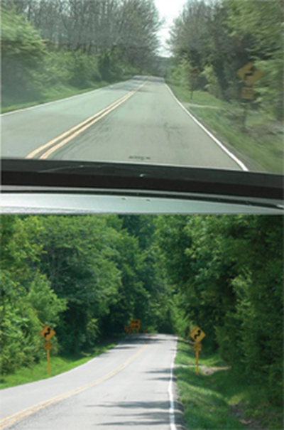
Figure 1. Before and After Photos of Sign Installation Completed as Part of Program.

"two photos of the same stretch of paved road, surrounded by trees on both sides: the top photo shows one yellow 'S'/30 MPH caution sign on the right side of the road; the bottom photo shows one on each side of the road and a third, large caution sign in the distance where the road begins to curve"
Source: Ohio Department of Transportation/LTAP


Benefit

The signage packages help insure the townships install the signs according to the requirements of the Ohio Manual of Uniform Traffic Control Devices (OMUTCD).

Contact

FHWA Office of Safety staff contacts by safety function

Nebraska Department of Roads and LTAPs Encourage Local Agency Participation in County Sign Installation Programs

Summary from Assessment of Local Road Safety Funding, Training, and Technical Assistance: Benefit/Cost Tool and Local Road Safety Manual


Background

The Nebraska Department of Roads (NDOR) Local Projects Division and Nebraska Local Technical Assistance Program (LTAP) Center provide a systemic county sign installation program. Many of Nebraska's 93 counties do not have a county engineer. The program started because the State was receiving few High Risk Rural Roads Program (HRRRP) project applications. To encourage participation from local agencies, NDOR conducts a systemic safety analysis to identify potential sites (e.g., horizontal curves) for safety improvements based on risk. To market the program, the NDOR takes advantage of the Nebraska LTAP Center's contacts at local agencies throughout the State. The LTAP Center meets with the county superintendents and city supervisors and provides crash data and information about the project application process. Project site locations are selected by the counties. Counties agree to install signs according to the requirements of the Nebraska Manual on Uniform Traffic Control Devices (MUTCD). The Nebraska LTAP Center conducts spot checks to ensure proper installations.

Benefits

The program has helped Nebraska successfully obligate safety funds, especially the HRRRP. The program has received participation from 78 of Nebraska's 93 counties.

Contact

FHWA Office of Safety staff contacts by safety function

Louisiana DOTD and LTAP Partnership Improves Local Agencies' Capabilities to Develop Regional Safety Plans, Access Funding, and Implement Safety Improvements

Summary from Assessment of Local Road Safety Funding, Training, and Technical Assistance: Benefit/Cost Tool and Local Road Safety Manual


Background

Louisiana Department of Transportation and Development (DOTD) established a Local Roads Safety Program in 2006 and despite early barriers and challenges, it has become a viable program aimed at improving highway safety on Louisiana's local road network. Today, the Louisiana Local Technical Assistance Program (LTAP) Center administers the Local Road Safety Program and DOTD sets aside $3 to $5 million from its Section 154 and 164 Safety Transfer funds, Highway Safety Improvement Program (HSIP) funds, and High Risk Rural Roads Program (HRRRP) funds for local safety projects. (Note: MAP-21 continues two penalty transfer programs to encourage States to enact Open Container laws (Section 154) and Repeat Intoxicated Driver laws (Section 164). Any State that does not enact and enforce a conforming open container and repeat intoxicated driver law will be subject to a penalty transfer of funds. Additional information is available on the MAP-21 Guidance page.) Thanks to the successful partnership between LTAP and DOTD, technical assistance and funding is available to help local agencies implement infrastructure projects.

Within DOTD, no unit or department is responsible for administering local road safety projects, which is one of the main reasons for the partnership with LTAP. The DOTD Office of Safety provides funding to LA LTAP for a full-time traffic safety engineer/program manager, a part-time project engineer and two part-time traffic safety engineers.

The main component of the Louisiana LTAP program is to help local agencies develop the capability to solve local road safety problems using local resources or by accessing funds through the Strategic Highway Safety Plan (SHSP) process. LTAP assists local agencies to identify, apply for, and administer local road infrastructure safety projects. Most recently, they have begun to assist the regional transportation safety coalitions with the identification and implementation of infrastructure improvements.

In 2011, DOTD divided the State into 10 regions and charged each with developing a regional safety coalition and a safety plan (a regional SHSP) to help with the implementation of the Louisiana SHSP. Each coalition reviews regional crash data to identify strategies and projects to reduce fatalities and serious injuries for impaired drivers, unbelted drivers, young drivers, and infrastructure-related crashes. LTAP works with the coalitions to identify and implement local infrastructure improvements for the plans in coordination with activities on the State system.

Benefits

To date, LTAP has provided local data, data analysis, and technical assistance to four regional coalitions. The most advanced coalition, the South Central Regional Transportation Safety Partnership, has conducted five Road Safety Audits (RSAs), and with the help of LTAP is preparing to apply for funding. LTAP also currently is working with coalition members (as well as individual parishes) to implement a system-wide/systemic approach to improving safety on horizontal curves. LTAP has located all horizontal curves on the local road system. LTAP is working with the local agencies and DOTD to develop a process to characterize and prioritize these curves based on certain criteria and to develop a manageable process to implement projects systemically.

In terms of next steps, LTAP, LSU, and DOTD are partnering on a three-year program to assemble roadway and traffic data on the local road system. This program will collect roadway characteristic and traffic data on all arterials, collectors and roads of significance for the local road system. This will continue to enhance LTAP's capability to work with the local agencies, share data, and collaborate on infrastructure improvements. LTAP is facilitating the development of a research project to develop better estimates of local road Annual Average Daily Traffic (AADT) which is necessary for many of the analytical tools currently being used to analyze for safety.

Contact

FHWA Office of Safety staff contacts by safety function

Ohio Local Road Safety Program's State and Local Collaboration Makes Safety a Local Priority

Summary from Assessment of Local Road Safety Funding, Training, and Technical Assistance: Benefit/Cost Tool and Local Road Safety Manual


Background

The Ohio Local Road Safety Program is a three-part collaboration among Ohio DOT (ODOT), the Ohio Local Technical Assistance Program (LTAP) center, and the County Engineers Association of Ohio (CEAO). The collaboration provides funding for local road safety improvements, offers training and technical assistance to local agencies, and assists with the administration of local safety projects.

ODOT dedicates $12 million of Highway Safety Improvement Program (HSIP) funds annually to qualifying safety projects on county roads. The funds are administered by CEAO. ODOT also funds a position at CEAO to administer the county safety projects and provide technical assistance to counties as they develop and implement local safety projects. Once projects are approved for safety funding, they are administered by ODOT through the district offices or by local governments through the Office of Local Programs. The funding set aside specifically for county roads has enabled county engineers to take the lead in determining the improvement projects to fund. Providing funding for a CEAO position enables counties to administer projects with the assistance of the CEAO Program Manager.

Local agencies also are eligible to apply for HSIP funds through the statewide program managed by ODOT. Multidisciplinary committees review applications each year and award funds based on scored criteria and other factors, such as cost, compatibility between countermeasures and crash patterns, and relevance to the Strategic Highway Safety Plan (SHSP). ODOT provides crash data and user-friendly tools to help local governments analyze safety challenges and justify public investments.

Ohio LTAP has developed educational, outreach, and Road Safety Audit (RSA) programs designed to build safety knowledge at the local level. Participation in RSA programs and training has increased now that an incentive is tied to local agency RSA participation. Typically ODOT will fund low-cost safety improvements on corridors or at spot locations where RSAs are conducted; however, if an RSA identifies the need for larger, more costly improvements, ODOT sends task order consultants to assess the problem and the costs.

Benefits

ODOT's partnerships with LTAP and CEAO have successfully made safety a local priority. With over 2,300 local agencies in Ohio, about 75 percent of these governments have taken advantage of the training, technical assistance, and tools provided by ODOT, Ohio LTAP, and CEAO.

Contact

FHWA Office of Safety staff contacts by safety function

ODOT's GCAT GIS Tool Helps Local Roadway Agencies Justify Funding Requests for Road Safety Improvement

Summary from Assessment of Local Road Safety Funding, Training, and Technical Assistance: Benefit/Cost Tool and Local Road Safety Manual


Background

Local roadway agencies need a method for obtaining the data necessary to justify funding requests for road safety improvement projects. The Ohio Department of Transportation (ODOT) developed a crash-mapping tool called GCAT (GIS Crash Analysis Tool), which is used to map the crashes occurring on the State's roadways. GCAT uses Geographic Information Systems (GIS) to produce spatially located (latitude/longitude) data. Crash data for all local roadways is available.

The tool is a web application and can be accessed from any computer on-line through the ODOT web site. Access to GCAT is free and easy to obtain for employees of the city, county, village, township, metropolitan planning organizations, law enforcement, and prequalified safety study consultants. Local agencies can submit a basic account request on-line and begin using the GCAT program once they are notified via email.

Benfit

Ohio DOT has seen an increase in project applications from local agencies as tools and training opportunities provide the means to justify safety problems and identify potential countermeasures.

Contact

FHWA Office of Safety staff contacts by safety function