
RSA No. 1 – Snake Hill Road, Glocester, Rhode Island
| Project Overview | |
| Project Location: | 7.4 miles of Snake Hill Road in Glocester, Rhode Island from approximately the Anan Wade Road intersection to the West Greenville Road intersection. |
| Project Environment: | Rural |
| Project Design Stage: | Existing roadway |
| Project Owner(s): | Rhode Island Department of Transportation |
| RSA Overview | |
| Date of RSA: | February 27, 2013 |
| RSA Stage(s): | RSA of existing roads |
| RSA Team: | Representatives from the Federal Highway Administration , Glocester Police Department, Town of Glocester, Rhode Island Department of Transportation, Rhode Island Statewide Planning, and Vanasse Hangen Brustlin, Inc. |
| IHSDM Overview | |
| Information Provided by Roadway Owner: | As-built construction plans.
Vertical data from Rhode Island GIS. Traffic data from RIDOT. Crash data from RIDOT. |
| IHSDM Modules Utilized: | Policy Review Module: Stopping Sight Distance, Passing Sight Distance, and Radius of Curve.
Design Consistency Module. Crash Prediction Module (using site-specific historical crash data). |
RSA No. 1 – Project Background
FHWA and the Rhode Island Department of Transportation (RIDOT) partnered to conduct an RSA on the Snake Hill Road corridor in Glocester, Rhode Island. The corridor was identified by RIDOT as having a crash rate higher than the statewide average. As such the roadway is eligible for funding improvements under the State’s Highway Safety Improvement Program (HSIP) and High Risk Rural Road Program (HRRR), making it a good candidate for conducting an RSA. Furthermore, the majority of the crashes were run-off-the-road or intersection related crashes, both of which are emphasis areas in Rhode Island’s Strategic Highway Safety Plan (SHSP).
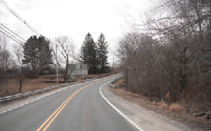
Snake Hill Road, shown in Figure 6, is an east-west rural major collector roadway under the jurisdiction of RIDOT. Within the assessment area, the road is a two-way, two-lane road consisting of a 12 foot wide travel lane and shoulders varying in widths between 2 and 8 feet. There is one signalized intersection and one intersection with a flashing beacon. There are also 28 unsignalized intersections within the corridor and approximately five driveways per mile. The roadside characteristics vary as well, with conditions ranging from clear, open areas to fixed objects within the clear zone, including trees, utility poles, and stone walls.
The posted speed limit on Snake Hill Road ranges from 35 to 40 miles per hour (mph) within the study area.
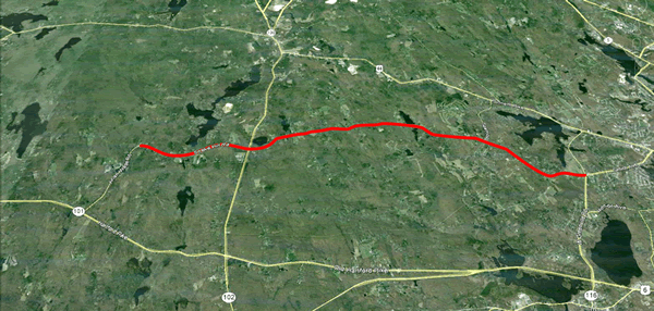
Figure 6: Snake Hill Road Corridor (Red).
RSA No. 1 – Use of IHSDM
The RSA team reviewed safety conditions on the Snake Hill Road corridor utilizing recent crash data, local and RSA team inputs, and IHSDM. IHSDM was used to help select sites for detailed review and to help identify priority areas where improvements should be considered. The IHSDM modules utilized were the Policy Review Module (PRM), the Design Consistency Module (DCM), and the Crash Prediction Module (CPM). It is important to note that current as-built drawings were not available for this RSA. Therefore, a method of estimating the design details was utilized for input into IHSDM as described in Section 1.5.
The IHSDM analysis produced output tables and graphs that illustrate locations where stopping sight distance was not met, policy values for horizontal curve length and radius were not met, the 85th percentile speed profile for the corridor traveling in each direction and accompanying "flagged" elements due to speed differential between tangent and curve sections of road, and projected crashes along the alignment. A summary of the IHSDM graphs is shown in Figure 7; however, the results by module can be summarized as follows:
PRM – Several locations did not meet the 2011 AASHTO minimum criteria for stopping sight distance (in Figure 7 see available sight distance plotted in green for the eastbound direction and required sight distance in gold) and radius of curve. Also, the section studied provided very few passing opportunities.
DCM – The output from this module showed that the expected reduction in estimated 85th percentile speeds from an approach tangent to its succeeding horizontal curve were all flagged as "green," indicating the speed differential is less than 6 mph (in Figure 7 see 85th percentile speed plotted for the eastbound direction with green flags indicating speed differential). Three locations that approached this threshold were noted, but overall, the projected speed along the alignment was fairly consistent.
CPM – Five years of site-specific crash history (87 reported crashes from January 1, 2008 to December 31, 2012) were used for the CPM analysis (the analysis period was 2013-2017) which is recommended for locations that have similar characteristics in the "before" and "after" analysis periods. The results provided a predicted 58.85 total crashes for the analysis period with a crash rate of 1.551 crashes/mi/yr. Expected crash rate (crashes/mi/yr) for each homogeneous roadway segment and horizontal design element are graphed as part of the standard IHSDM output (see Figure 7). The roadway design elements with the highest expected crash rates were tangents with intersections and curve segments of the roadway.
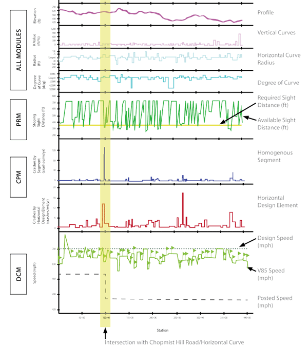
Figure 7: Summary of Snake Hill IHSDM Road Graphical Output.
The output from the various modules was compared through tables (Figure 7) and maps (Figure 8), to help identify critical locations for assessment. Results for each module were ranked (with the number "1" identifying the most critical condition) to help provide a measure of risk for the identified locations
as critical through IHSDM. For example, the intersection with Chopmist Hill Road was the second most critical location according to the CPM, and the 31st most critical in terms of available sight distance. However, it should be noted that the difference in the ranked locations may be minor in some cases, for example there may be little difference between the 10th and 30th ranked locations. For this reason the required IHSDM output should be used for the more detailed assessment.
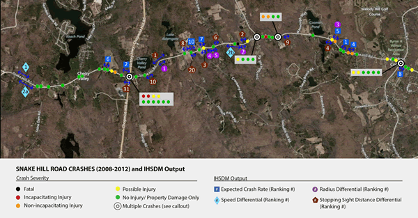
Figure 8: Section of Snake Hill Road with Crashes (2008-2012) and IHSDM Output Results.
RSA No. 1 – Key RSA Findings and Suggestions
The results of these models confirmed the following intersections with Snake Hill Road as critical "spot" locations along the corridor:
- Chopmist Hill Road (Route 102), which experienced 10 crashes.
- Sawmill Road (not shown in Figure 4), which experienced 6 crashes.
- Elmdale Drive (not shown in Figure 4), which experienced 8 crashes.
Of the spot locations, the Chopmist Hill Road and Elmdale Drive intersections were ranked second and third highest, respectively, for expected crash rate by the CPM. The Sawmill Road intersection was ranked fourth for the differential between the available and required stopping sight distance. The three intersections are located close to horizontal curves and had sight distance limitations as observed from the field review. All three intersections also ranked high in terms of the number of reported crashes. Other intersections were reviewed but had less critical crash records, which was confirmed by the IHSDM analysis. Figure 9 shows an aerial view of the intersection with Elmdale Drive and the proximity of the horizontal curve. Note the user-defined project stationing provides scale (i.e., 100 feet between stations).
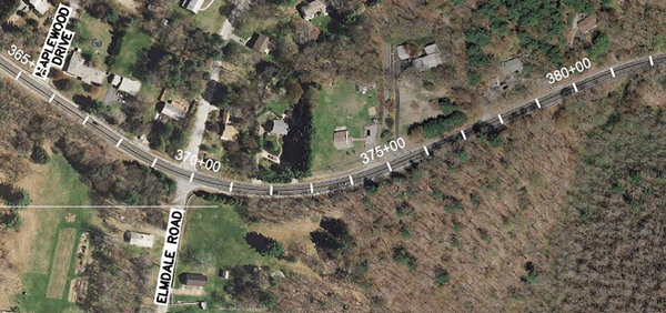
Figure 9: Corridor Stationing Diagram (source: Google Earth).
The key issues and suggested mitigation actions associated with the three intersections are summarized in Table 3.
Table 3: Snake Hill Road: Site-specific safety issues and suggested mitigations.
| Selected Safety Issue | Suggested Action |
|---|---|
| Snake Hill Road at Chopmist Road (Route 102) | |
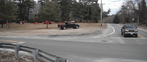
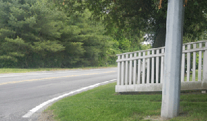
| Roadside Fixed Objects The guardrail along the northeast corner of the intersection is visibly damaged as the result of previous collisions. This damage may be the result of a vehicle ricochet from a crash in the intersection or may indicate that speed or roadway conditions are a factor in collisions at the intersection.
Damaged guardrail in the northeast corner. The utility pole and span wire pole located along the east side of Snake Hill Road may constitute a fixed object obstruction for vehicles departing the roadway. |
Short Range: Repair and enhance conspicuity of guardrail. Improve conspicuity of fixed objects with reflective tape or object markers. Intermediate Range: Perform a speed study on Snake Hill Road in the study area to assess the average and 85th percentile traffic speeds. Consider speed-related mitigation measures pending the findings of the speed study. Intermediate/Long Range: Consider roadway improvements to remove guardrail and provide a recovery area. Long Range: Consider relocating the utility pole out of the required clear zone in combination with other intersection redesign elements. |
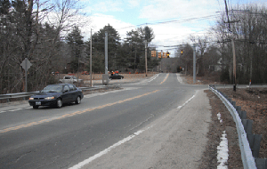
| Intersection Conspicuity and Sight Distance The eastbound approach is aligned along a horizontal curve, which may limit sight distance of the traffic signal or stopped vehicles, contributing to rear end and other intersection-related collisions.
View of the intersection looking west, showing the horizontal curve west of the intersection (far-side). On the near-side of the intersection (east side) a utility pole and span wire pole are located in the clear zone. |
Short Range: Remove or trim vegetation to improve sight distance on the horizontal curve on the west side of the intersection. Install an intersection warning sign (W2-1) and/or Signal Ahead sign (W3-3) on eastbound Snake Hill Road in advance of the intersection. Intermediate Range: Conduct analysis to improve operational efficiency considering sight distance and queuing on the eastbound approach. This may include the following improvements: providing turn lanes, improving drainage (level), and providing a recovery area (e.g., full-width paved shoulders). |
| Pavement Marking Condition and Roadside Debris The conspicuity of the Stop bar on eastbound Snake Hill Road approaching the intersection is poor. Sand and gravel were observed on the shoulder approaching the intersection diminishing visibility of the edgeline.
Conspicuity of Stop bar on eastbound approach is poor and loose debris is present in the shoulder. |
Short Range: Refresh the Stop bar pavement markings at the intersection. Remove loose debris from the shoulders and roadway surface. Intermediate Range: Consider using higher-visibility pavement marking materials for Stop bar markings at this intersection. |
| Snake Hill Road at Sawmill Road | |
| Vehicle Right-Of-Way Confusion Vehicles on Snake Hill Road were observed to yield to the vehicles waiting to enter the intersection from Sawmill Road. This caused conflicts with vehicles traveling through the intersection that do not anticipate the need to yield or stop to side street traffic.
|
Intermediate Range: Evaluate the need for a full traffic signal at this location based on safety, available sight distance, and operational characteristics (including traffic volume). Provide supplementary messages to motorists on Snake Hill Road. |
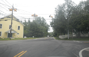
| Intersection Visibility, Sight lines on the south approach to Snake Hill Road are limited by foliage. These limitations may obstruct vehicles from seeing the traffic control devices (flashing red signal and stop sign) on this approach. There is ambient lighting near the intersection (in particular from the gas station in the northwest corner), which may cancel the effects of the low-intensity intersection lighting. Foliage obstructs the view of the overhead flashing signal and stop sign on the Sawmill Road south approach. |
Short Range: Remove vegetation or trim vegetation to provide full visibility of the intersection. Intermediate Range: Perform a sight distance evaluation to assess the adequacy of stopping and intersection sight distances on this roadway segment. Pending the findings of this evaluation, further mitigation measures may be recommended. Enhance lighting at the intersection. Intersection lighting helps drivers to identify the location of intersections at night, to define the limits of the intersection, and to see and expect vehicle turn movements. |
| Sight Distance Obstructions The southwest corner of the intersection contains a fence that may obstruct sight distance for vehicles stopped on Sawmill Road. The eastbound approach is aligned along a curve, which may limit sight distance of the traffic signal or stopped vehicles and contribute to rear end collisions.
A wooden fence on obstructs the sight lines along the southern leg of the intersection. |
Intermediate Range: Perform a sight distance evaluation to assess the adequacy of stopping and intersection sight distances on this roadway segment. Pending the findings of this evaluation, further mitigation measures may be recommended. |
| Snake Hill Road at Elmdale Road | |
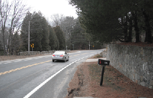
| Roadside Fixed Objects and Vehicle Speed The rock wall located in the roadside along the north (westbound) edge of Snake Hill Road constitutes a fixed object obstruction for vehicles departing the roadway. Vehicle speeds may be too fast for conditions (e.g., sharp curve, intersection, and roadside fixed objects). Excessive vehicle speeds in this area may contribute to loss of vehicle control.
Retaining wall and utility poles along westbound Snake Hill Road. |
Short Range: Review offset of the retaining wall from the traveled way on Snake Hill Road and assess clear zone requirements based on AASHTO criteria. Perform a speed study on Snake Hill Road in the study area to assess the average and 85th percentile traffic speeds. Intermediate Range: Consider speed-related mitigation measures pending the findings of the speed study, such as modifying the size and spacing of chevrons to provide greater in-curve speed reductions, speed feedback signs or dynamic curve warning signs. |
| Sight Distance Obstructions Sight lines along the northern edge of the curve are limited by the retaining wall and a crest vertical curve. These limitations may obstruct sight distance for vehicles traveling on westbound Snake Hill Road or vehicles exiting from Pinecrest Drive (opposite Elmdale Drive) or private driveways.
A retaining wall and crest limit sight lines along the northern edge of the curve. |
Short Range: Post an advisory speed limit sign (W13-1P) with the existing intersection warning sign on westbound Snake Hill Road. Perform a sight distance evaluation to assess the adequacy of stopping and intersection sight distances on this roadway segment. Pending the findings of this evaluation, further mitigation measures may be recommended. Intermediate Range: Should intersection sight distance remain constrained, consider installing actuated flashing beacons on the intersection warning signage to inform approaching drivers that a turning vehicle is present at Elmdale Road/ Pinecrest Drive. |

The output of the model also highlighted potential issues on several curves along the corridor. Specific issues included the following:
- PRM: insufficient stopping sight distance, not meeting 2011 AASHTO policy for radius of curve.
- DCM: speed differential, although none were high levels of concern.
- CPM: elevated crash potential. The most prevalent characteristic that elevated crash potential were curve length and/or radius, with shorter lengths and radii having the higher predicted crash potential.
The RSA team evaluated several of the critical curves on the corridor and identified attributes of the roadway geometry, markings, sight distance, and roadside conditions that may contribute to crashes as suggested in the IHSDM methodology. A summary of the key systemic safety issues on curves and suggested mitigation actions for the Snake Hill RSA is contained in Table 4.
Table 4: Snake Hill Road: Key systemic safety issues and suggested mitigating actions.
| Selected Safety Issue | Suggested Action |
|---|---|
| Speed and Loss of Control
In some locations, roadside vegetation and guardrail is visibly damaged as the result of previous collisions. The roadside damage suggests a vehicle may have departed the roadway prior to the beginning of the guardrail or the guardrail was recently repaired. A loss of control crash may suggest that speed or pavement conditions on Snake Hill Road are contributing factors.
Damaged roadside vegetation indicates a possible loss of control crash. |
Short Range: Repair existing guardrail along Snake Hill Road. Consider enhancing delineation through curve for guidance during low-light conditions. Perform a speed study on Snake Hill Road in the study area to assess the average and 85th percentile traffic speeds. Consider speed-related mitigation measures such as speed feedback signs pending the findings of the speed study. Intermediate Range: Review detailed crash data records in proximity to the curve to assess the role of weather and pavement conditions on loss-of-control crashes. |
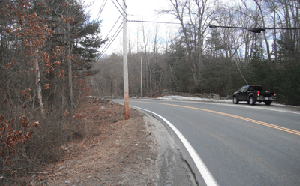
| Roadside Fixed Objects In some locations, utility poles and span wire poles located along Snake Hill Road may constitute a fixed object obstruction for vehicles departing the roadway.
Utility pole along westbound Snake Hill Road. |
Short Range: Review offset of utility pole from the traveled way on Snake Hill Road and assess clear zone requirements based on AASHTO criteria. Pending results, consider installing guardrail. Improve conspicuity of fixed objects with reflective tape or object markers. Long Range: Consider relocating the utility pole out of the required clear zone, potentially in combination with other roadside projects. |
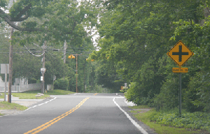
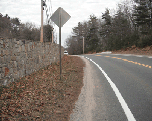
| Curve Delineation/Visibility Limited curve delineation on Snake Hill Roadway may contribute to loss of control crashes. Some curves are delineated only by the centerline and edgeline striping. Some curves contain vegetation, walls, or other features that may obstruct sight distance for vehicles traveling on Snake Hill Road or vehicles exiting from driveways onto Snake Hill Road.
Westbound Snake Hill Road approaching a curve. |
Short Range: Consider installing advance warning curve signage on both eastbound and westbound approaches to curves. Consider installing chevron signs (W1-8R) along the outside edge of the curve, visible to traffic in both directions. Intermediate Range: Consider installing a supplemental or integrated speed advisory signage (W1-2a or W13-1P) with advance warning curve signage. |
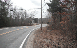
| Limited Shoulder and Pavement Edge Drop-off The pavement edge along some curves on Snake Hill Road ends in a jagged drop-off within six inches of the painted edgeline. This condition may contribute to loss of control crashes for vehicles that drift across the edgeline, and can be particularly problematic for motorcycles. Limited shoulder area provides little opportunity for driver recovery.
Pavement edge condition along a curve. |
Short Range: Install post-mounted delineators to provide high-visibility delineation. Intermediate Range: Widen shoulders along the curve to provide additional recovery area. Install a safety edge treatment at the edge of the roadway to minimize loss of control potential for vehicles departing the roadway. |

RSA No. 1 – Conclusion
IHSDM provided quantitative safety information to the RSA team that helped focus the team’s efforts on key issues along a corridor of substantial length. These critical locations reviewed by
the RSA team include specific locations flagged by IHSDM, and historic crash data that had unique characteristics as well as locations that had similar features. The results of the IHSDM models confirmed several intersections with Snake Hill Road as critical "spot" locations along the corridor and horizontal curves on the corridor.
Specific safety measures were suggested for the spot locations (i.e., intersections). Improvements on horizontal curves were suggested based on a systemic deployment strategy that considers risk. Implementing a systemic strategy to deploy curve countermeasures will improve the effectiveness of measures, which may otherwise be undermined through overuse or inappropriate use. For this reason, strategies to deploy delineation measures may be well served to compare current deployment criteria or methods, such as conducting a ball bank test, to other quantitative analyses, such as those provided in IHSDM.